Thursday, October 20, 2005
The Mercurial Emperor's Tomb
This morning I was checking the news while eating breakfast and I came across this story on the BBC:
Royal Chinese treasure discovered
I've been there. I stood on top of the mound and looked around at the pomegranate groves and fields surrounding it. It is actually quite a ways from the opened pits of terra cotta soldiers which we had just toured, so one can only imagine how many more pits of warriors and what all left. They're really waiting for better preservation techniques before they open anything else, though, because we know that the current warriors were all painted bright colors that oxidized within minutes of excavators breaking through.
The story that I heard of why they really don't want to open the tomb mound itself, though, has to do with mercury. The written plans and descriptions they have found for the tomb say that the emperor called for a jeweled representation of the heavens to cover the ceiling, and a jeweled map of his empire to cover the floor, complete with a flowing river of mercury, which the emperor believed would make him immortal. Therefore, it is believed that the tomb contains many wonders too magnificent to wish to damage with insufficient preservation, but also a great deal of mercury that has been in an enclosed space for a very, very long time, and they're not sure what it's done in the meantime. In the interest of not poisoning the archeologists and other workers while opening the tomb, they're not too keen on doing so until they're sure they can contain the mercury, whatever state it may be in.
This morning I was checking the news while eating breakfast and I came across this story on the BBC:
Royal Chinese treasure discovered
The burial mound covering the tomb [of China's first emperor] has remained largely untouched by archaeologists for fear of damaging the treasures it contains.
But the magnetic scan of the area, conducted by Chinese and German archaeologists, revealed new details about the structure of the mausoleum and a "remarkable amount of coins," the official Xinhua news agency reported.
I've been there. I stood on top of the mound and looked around at the pomegranate groves and fields surrounding it. It is actually quite a ways from the opened pits of terra cotta soldiers which we had just toured, so one can only imagine how many more pits of warriors and what all left. They're really waiting for better preservation techniques before they open anything else, though, because we know that the current warriors were all painted bright colors that oxidized within minutes of excavators breaking through.
The story that I heard of why they really don't want to open the tomb mound itself, though, has to do with mercury. The written plans and descriptions they have found for the tomb say that the emperor called for a jeweled representation of the heavens to cover the ceiling, and a jeweled map of his empire to cover the floor, complete with a flowing river of mercury, which the emperor believed would make him immortal. Therefore, it is believed that the tomb contains many wonders too magnificent to wish to damage with insufficient preservation, but also a great deal of mercury that has been in an enclosed space for a very, very long time, and they're not sure what it's done in the meantime. In the interest of not poisoning the archeologists and other workers while opening the tomb, they're not too keen on doing so until they're sure they can contain the mercury, whatever state it may be in.
Sunday, October 16, 2005
Canyonlands
The Utah Adventure, Part III
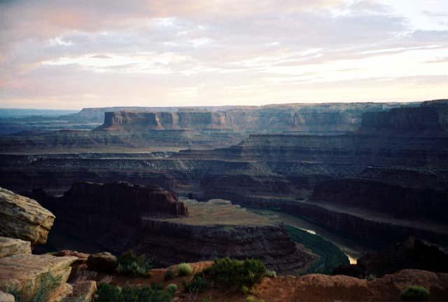
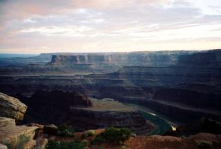 On the evening after our second day in Arches NP, we drove a bit further up the road out of Moab to Dead Horse Point State Park. The view, as you can see, was quite spectacular, and even moreso because we were there at sunset. The triangular bit of land you can see there is called Dead Horse Point because cowboys used to use it as a natural corral for wild horses since the drop is so steep at the point, roping the horses they wanted and letting the rest go afterward. One of the less responsible cowboys, though, left his herd trapped and wandered off, leaving them to die of dehydration.
From the Dead Horse Point overlook, though, what you are really looking out into is not the state park, but Canyonlands National Park. This park is so big, it has been divided into three separate districts, Needles, Island in the Sky, and the Maze, each with its own entrance and divided from the other districts by the Green and White Colorado Rivers forming natural boundaries within the park. It is actually one of the less mapped and trailed parks that I've been to in the US, so if you want to see much of the districts, you have to be prepared for some serious hiking and camping. What has been trailed out, though, is enough to give you a definite desire to see more.
 The next day we set out for the Needles district. Its entrance is actually about 2 hours away from Moab, and the land takes on quite a different aspect just that far away from Arches. While Arches is mostly red rock and desert feel, Needles has a lot more green on its rocks. In addition, while Arches struck me as a very interactive park where you felt like you could walk up and touch the rocks, Canyonlands is much more sweeping vistas and majestic canyons that can only be taken in from afar. We nearly had the park to ourselves because, about 20 minutes after arriving, it began to rain quite hard. We retreated to the visitor center parking lot and entertained ourselves by playing travel Scrabble in the car until the rain stopped. When it did let up and we could see again, pretty much everyone else had given up and left.
 We ended up doing the Slickrock Trail, one of the shorter ones in the park, because by the time the rain ended, we didn't have 4-5 hours to devote to one hike before it got too dark to find our way back to the car. According to the map, Slickrock will only take 2 hours. We probably spent 3 or more, because we took every single minor branch to an overlook, and paused to look at neat things. The whole trail was marked only with stone cairns on the slickrock, which led to several moments of "Wait, where do we go now?" and looking around for the next pile of rocks, but we learned to trust that the park service knew what it was doing in setting out the trail, because each overlook point we came to was spectacular. With all the rain, too, Andrew decided that all the strange, wet rock formations looked like what Mars would be if there was rain and vegetation. When the sun went down, though, we had to go, with the wish that we had come more prepared to do more serious exploration.
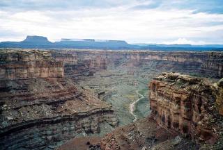
 The next day we hit the Island in the Sky district of the park, which is the district Dead Horse Point Park looks into. The entrance to Island in the Sky is conveniently located on the way out of Moab. I say convenient because this was our last day in the area. We had to be back in Salt Lake City by that evening so we could get to the airport in time the next day. In quite a change from our previous lack-of-schedule existence on this vacation, this day I had a schedule in mind, with the best route of all the important sights of the park mapped out with suggestions from a park ranger at the visitor's center. Andrew did not particularly like being zipped through the park in such a manner, but he will have to admit that we saw pretty much the whole thing in 3 hours. We started out at the Upheaval Dome, which entailed a short hike to get to the overlook of the extremely bizarre land formation which is either a salt dome that has been pushed up out of the earth or a meteor impact crater. Given that it is more than 90 million years old, though, all the evidence that would tell us whether it was a meteor impact crater for sure has long since eroded. The salt dome theory is the more accepted one now, which you can read more about at the link above.
 Besides this geological oddity, though, what Island in the Sky is really known for is its views. It truly is like looking down from an island in the sky, because the canyons are so far below you. Looking at my pictures now, they practically look like I took them from an airplane. We only got to do the short little hikes out to the various overlooks, but they were definitely worth it. When we hiked out to Mesa Arch, Andrew of course had to climb on top, which no one had really thought anything of in Arches, but here in the more sedate, viewing-oriented climate of Canyonlands had German tourists taking pictures of him. It seemed a fitting end to the vacation adventure.
On the way back to Salt Lake City, we stopped back by the dinosaur museum in Price to get an insanely bright stuffed dinosaur for baby Daniel, Selwyn the neon orange and raspberry plush chasmosaur, which we presented to Daniel's parents upon seeing them again before retiring to a hotel. Marian has since reported that Selwyn has become Daniel's favorite toy, I suspect mostly due to the brightness of coloration. Alas, the next day we did indeed have to wake up and board planes to return to our mundane lives, far from strange geological wonders and fantastic hiking trails.
The Utah Adventure, Part III
 On the evening after our second day in Arches NP, we drove a bit further up the road out of Moab to Dead Horse Point State Park. The view, as you can see, was quite spectacular, and even moreso because we were there at sunset. The triangular bit of land you can see there is called Dead Horse Point because cowboys used to use it as a natural corral for wild horses since the drop is so steep at the point, roping the horses they wanted and letting the rest go afterward. One of the less responsible cowboys, though, left his herd trapped and wandered off, leaving them to die of dehydration.
From the Dead Horse Point overlook, though, what you are really looking out into is not the state park, but Canyonlands National Park. This park is so big, it has been divided into three separate districts, Needles, Island in the Sky, and the Maze, each with its own entrance and divided from the other districts by the Green and White Colorado Rivers forming natural boundaries within the park. It is actually one of the less mapped and trailed parks that I've been to in the US, so if you want to see much of the districts, you have to be prepared for some serious hiking and camping. What has been trailed out, though, is enough to give you a definite desire to see more.
 The next day we set out for the Needles district. Its entrance is actually about 2 hours away from Moab, and the land takes on quite a different aspect just that far away from Arches. While Arches is mostly red rock and desert feel, Needles has a lot more green on its rocks. In addition, while Arches struck me as a very interactive park where you felt like you could walk up and touch the rocks, Canyonlands is much more sweeping vistas and majestic canyons that can only be taken in from afar. We nearly had the park to ourselves because, about 20 minutes after arriving, it began to rain quite hard. We retreated to the visitor center parking lot and entertained ourselves by playing travel Scrabble in the car until the rain stopped. When it did let up and we could see again, pretty much everyone else had given up and left.
 We ended up doing the Slickrock Trail, one of the shorter ones in the park, because by the time the rain ended, we didn't have 4-5 hours to devote to one hike before it got too dark to find our way back to the car. According to the map, Slickrock will only take 2 hours. We probably spent 3 or more, because we took every single minor branch to an overlook, and paused to look at neat things. The whole trail was marked only with stone cairns on the slickrock, which led to several moments of "Wait, where do we go now?" and looking around for the next pile of rocks, but we learned to trust that the park service knew what it was doing in setting out the trail, because each overlook point we came to was spectacular. With all the rain, too, Andrew decided that all the strange, wet rock formations looked like what Mars would be if there was rain and vegetation. When the sun went down, though, we had to go, with the wish that we had come more prepared to do more serious exploration.
 The next day we hit the Island in the Sky district of the park, which is the district Dead Horse Point Park looks into. The entrance to Island in the Sky is conveniently located on the way out of Moab. I say convenient because this was our last day in the area. We had to be back in Salt Lake City by that evening so we could get to the airport in time the next day. In quite a change from our previous lack-of-schedule existence on this vacation, this day I had a schedule in mind, with the best route of all the important sights of the park mapped out with suggestions from a park ranger at the visitor's center. Andrew did not particularly like being zipped through the park in such a manner, but he will have to admit that we saw pretty much the whole thing in 3 hours. We started out at the Upheaval Dome, which entailed a short hike to get to the overlook of the extremely bizarre land formation which is either a salt dome that has been pushed up out of the earth or a meteor impact crater. Given that it is more than 90 million years old, though, all the evidence that would tell us whether it was a meteor impact crater for sure has long since eroded. The salt dome theory is the more accepted one now, which you can read more about at the link above.
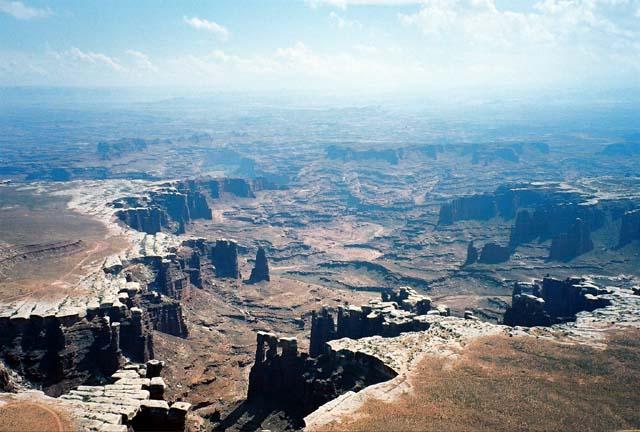 Besides this geological oddity, though, what Island in the Sky is really known for is its views. It truly is like looking down from an island in the sky, because the canyons are so far below you. Looking at my pictures now, they practically look like I took them from an airplane. We only got to do the short little hikes out to the various overlooks, but they were definitely worth it. When we hiked out to Mesa Arch, Andrew of course had to climb on top, which no one had really thought anything of in Arches, but here in the more sedate, viewing-oriented climate of Canyonlands had German tourists taking pictures of him. It seemed a fitting end to the vacation adventure.
On the way back to Salt Lake City, we stopped back by the dinosaur museum in Price to get an insanely bright stuffed dinosaur for baby Daniel, Selwyn the neon orange and raspberry plush chasmosaur, which we presented to Daniel's parents upon seeing them again before retiring to a hotel. Marian has since reported that Selwyn has become Daniel's favorite toy, I suspect mostly due to the brightness of coloration. Alas, the next day we did indeed have to wake up and board planes to return to our mundane lives, far from strange geological wonders and fantastic hiking trails.
Sunday, October 09, 2005
Happy Hangul Day!
We interrupt our previously scheduled accounting of the trip to Utah to bring you this public service announcement. Today is Hangul Day in South Korea, a day on which Koreans celebrate the creation of their writing system, hangul, in 1446, which allowed them freedom from the oppresssion of the highly irritating and irrational Chinese writing system previously in place.
As King Sejong wrote when he introduced his new system of writing to his country:
Anyway, I find this particularly interesting because I think my Korean students tried to explain Hangul Day to me before, but with much less detail. I would like to take this opportunity to point out to the Japanese that they had a perfectly good thing going on with just the two kana syllabaries, and they didn't really need to adopt all those kanji characters. See? Just look at the Koreans. Follow their sane example. A writing system actually related to the sounds in your spoken language is a good thing.
[Hangul information brought to you via Language Log]
We interrupt our previously scheduled accounting of the trip to Utah to bring you this public service announcement. Today is Hangul Day in South Korea, a day on which Koreans celebrate the creation of their writing system, hangul, in 1446, which allowed them freedom from the oppresssion of the highly irritating and irrational Chinese writing system previously in place.
As King Sejong wrote when he introduced his new system of writing to his country:
The sounds of our country's language are different from those of China and do not correspond to the sounds of Chinese characters. Therefore, among the stupid people, there have been many who, having something to put into writing, have in the end been unable to express their feelings. I have been distressed by this and have designed twenty-eight new letters, which I wish to have everyone practice at their ease and make convenient for their daily use.
Anyway, I find this particularly interesting because I think my Korean students tried to explain Hangul Day to me before, but with much less detail. I would like to take this opportunity to point out to the Japanese that they had a perfectly good thing going on with just the two kana syllabaries, and they didn't really need to adopt all those kanji characters. See? Just look at the Koreans. Follow their sane example. A writing system actually related to the sounds in your spoken language is a good thing.
[Hangul information brought to you via Language Log]
Thursday, October 06, 2005
Arches National Park
The Utah Adventure, Part II
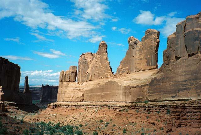
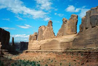 Our first two days in Moab were dedicated to Arches National Park, and I wish it could have been more. It is such a spectacular park. Our first hike was along the Park Avenue area of fins, as you can see in the picture. Early hikers thought these formations looked like a New York skyline, hence the name. It was a beautiful day, but since this was our first venture into hiking territory, it was also our first lesson in just how necessary it was to take water absolutely everywhere. (*Geek Note: If you have ever seen Indiana Jones and the Last Crusade, you may recognize a lot of the Arches scenery from the opening sequence, when the young Indy was on a scout troop trail ride.)
 We continued into the park, stopping at some of the smaller trails and viewpoints along the way. One of the most notable was Balanced Rock. It has been formed because there are different types of rock making up the top rock and the neck underneath it, which is eroding faster than the top. Eventually, of course, the top rock will fall off, as happened to a smaller version of it that used to stand nearby.
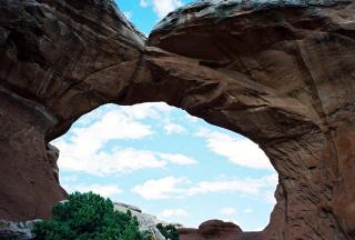
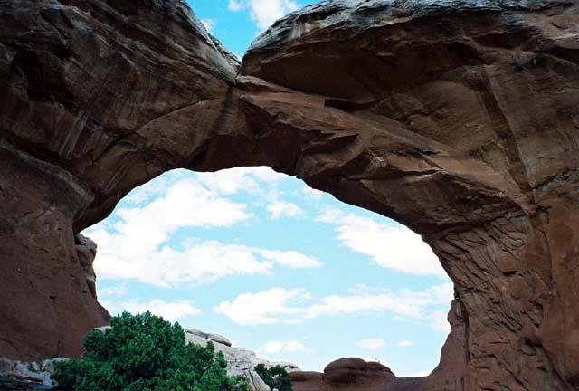
 Next we hit the Windows. There are really two main windows, North and South, and then a nearby circle of stone and arch called the Turret Arch. The North Arch is quite spectacular as the first thing you see, but it was nearly impossible to get a good picture of without 20 different tourists of 5 different nationalities standing in front of it, so my best picture is of the South Window, which is sort of around back. The Turret Arch was the most fun to walk around, though, because you can go inside it and walk all around, sort of like a castle.
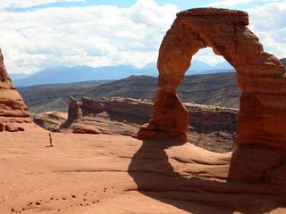 Our final stop for the first day was the Delicate Arch overlook. Delicate Arch is probably the most famous sight in the park. We didn't have time that afternoon to hike all the way up to it, though, so we looked at it from afar. I liked doing it this way, because the arch was that much more impressive when we actually got up to it on the second day. The hike up to it is mostly over slickrock, and very steep, but very satisfying. It was again quite hot and sunny, but we weren't in a hurry and had plenty of water, so we stopped to admire the view whenever there was some shade. The end was definitely worth it. Also, since we were crazy people who went in the middle of the day, there weren't that many other people up there, and we could walk out to the arch itself. Note that the tiny person in the picture is me.
Further along the road, we went to Sand Dune Arch, which is hidden back amongst a bunch of higher rocks, and you have to walk through a very narrow passage to reach it. All of the ground underneath it is much softer sand than we saw anywhere else, so I presume that's how it got its name. Andrew, of course, had to entertain himself by climbing up on top of it, but I declined, in case he fell off and I needed to run find help. I did convince him not to jump off.
 The Sand Dune Arch trail connects to the longer loop trail leading to Broken Arch, which of course we had to take. We had this trail mostly to ourselves, and it leads directly through the arch and into some very interesting winding paths through steep canyonlets.
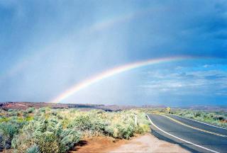 Unfortunately, by the time we found our way back to the car from Broken Arch, we had run out of time to do the ultimate hike in the park, Devil's Garden, which can take up to 5 hours. It had also started to rain, but this turned out to be a gift, because we got to start our drive back out of the park with the biggest, brightest, most distinct rainbow I've ever seen.
The Utah Adventure, Part II
 Our first two days in Moab were dedicated to Arches National Park, and I wish it could have been more. It is such a spectacular park. Our first hike was along the Park Avenue area of fins, as you can see in the picture. Early hikers thought these formations looked like a New York skyline, hence the name. It was a beautiful day, but since this was our first venture into hiking territory, it was also our first lesson in just how necessary it was to take water absolutely everywhere. (*Geek Note: If you have ever seen Indiana Jones and the Last Crusade, you may recognize a lot of the Arches scenery from the opening sequence, when the young Indy was on a scout troop trail ride.)
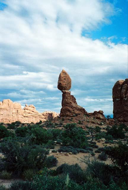 We continued into the park, stopping at some of the smaller trails and viewpoints along the way. One of the most notable was Balanced Rock. It has been formed because there are different types of rock making up the top rock and the neck underneath it, which is eroding faster than the top. Eventually, of course, the top rock will fall off, as happened to a smaller version of it that used to stand nearby.
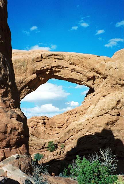 Next we hit the Windows. There are really two main windows, North and South, and then a nearby circle of stone and arch called the Turret Arch. The North Arch is quite spectacular as the first thing you see, but it was nearly impossible to get a good picture of without 20 different tourists of 5 different nationalities standing in front of it, so my best picture is of the South Window, which is sort of around back. The Turret Arch was the most fun to walk around, though, because you can go inside it and walk all around, sort of like a castle.
 Our final stop for the first day was the Delicate Arch overlook. Delicate Arch is probably the most famous sight in the park. We didn't have time that afternoon to hike all the way up to it, though, so we looked at it from afar. I liked doing it this way, because the arch was that much more impressive when we actually got up to it on the second day. The hike up to it is mostly over slickrock, and very steep, but very satisfying. It was again quite hot and sunny, but we weren't in a hurry and had plenty of water, so we stopped to admire the view whenever there was some shade. The end was definitely worth it. Also, since we were crazy people who went in the middle of the day, there weren't that many other people up there, and we could walk out to the arch itself. Note that the tiny person in the picture is me.
Further along the road, we went to Sand Dune Arch, which is hidden back amongst a bunch of higher rocks, and you have to walk through a very narrow passage to reach it. All of the ground underneath it is much softer sand than we saw anywhere else, so I presume that's how it got its name. Andrew, of course, had to entertain himself by climbing up on top of it, but I declined, in case he fell off and I needed to run find help. I did convince him not to jump off.
 The Sand Dune Arch trail connects to the longer loop trail leading to Broken Arch, which of course we had to take. We had this trail mostly to ourselves, and it leads directly through the arch and into some very interesting winding paths through steep canyonlets.
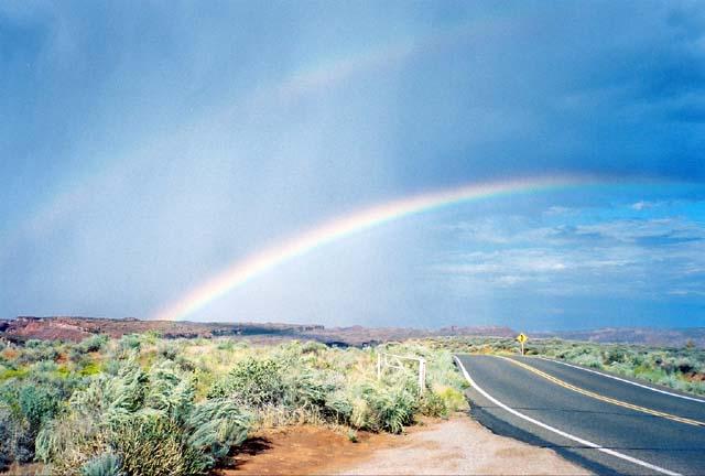 Unfortunately, by the time we found our way back to the car from Broken Arch, we had run out of time to do the ultimate hike in the park, Devil's Garden, which can take up to 5 hours. It had also started to rain, but this turned out to be a gift, because we got to start our drive back out of the park with the biggest, brightest, most distinct rainbow I've ever seen.
Tuesday, October 04, 2005
All Hail the National Parks Service
or, The Utah Adventure: Part I
While my dear homeland may have dropped the ball on running a decent public transportation system, it has managed to do one thing right: the National Park Service. I have been remiss in my blogging, but last month, Sept. 4-10, I took a trip to Moab, Utah, and decided that maybe being an American isn't all bad after all.
The excuse for the trip was that my friend Andrew has been needing to take a vacation for forever and ever, but didn't want to go by himself, and being unemployed at the time, it seemed like a good use of my free time to suggest to him that perhaps now was a good time for a vacation. I'm selfless that way. A saint, that's me. I expect to be beatified any day as the patron saintess of vacations. In any case, it turned out that he was a perfect person to take a trip to the Southwest with, given his wide knowledge of biology, geology, and paleontology (as well as his non-annoying taste in car music.) Let the educational adventure begin!
Well, almost begin. On the day we arrived in Utah, we had to start by visiting friends from college who are now living in Salt Lake City. Since Marian and the other Andrew have just had a baby, there was much oohing and aahing amongst the requisite Grinnell gossip. Yay, fun people! But then we did hit the road towards Moab and the next day got all the way to... Timpanogos Cave, which isn't actually that far away. It was, however, very cool.
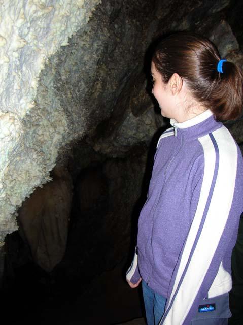
 To get to the cave, you have to hike for miles up the steepest path I've ever seen paved, with many switchbacks, and occasional stretches painted red where you're not allowed to stop and rest because rocks might fall on you. It was a beautiful day, though, and the scenery was beautiful. The cave is almost at the top of the mountain, and is famous for having the one of the largest cave lakes in... some geographic area. (The US? The world? I don't remember.) As it turns out, though, to be a cave lake, the water only has to be 1 ft. x 1 ft x 1 ft, and the big one is in a cavern you have to do the special spelunking tour to get to. Oh, well. What we did see was pretty anyway.
When we got out of the cave and back down the mountain, I had worked muscles I didn't even know I had. I think it was a good way to start the vacation, though, because it didn't give my body any illusions that it would be able to slack off.
 We got back on the road after the cave tour and made it this time as far as Price, Utah. This was the site of Andrew's famous facial repair, (for which story you can read his account,) as well as the more exciting Prehistoric Museum. Andrew proceeded to wander around in ecstasy until they closed the museum for the day, pointing out various things of interest just sitting on the floor, which he insisted would have been prized pieces in any other museum. They also had an very exciting statue of their famed Utahraptor at the entrance to the parking lot. He is posed in a rather dramatic kung-fu-esque stance, and amused me no end.
Once they closed the museum, though, we did finally get back in the car and drive the rest of the way to Moab, where we checked in to the Lazy Lizard Hostel and got our very own cabin! So cute. And then, sleep, because the next day we had to get up and start exploring the joys of Arches National Park!
or, The Utah Adventure: Part I
While my dear homeland may have dropped the ball on running a decent public transportation system, it has managed to do one thing right: the National Park Service. I have been remiss in my blogging, but last month, Sept. 4-10, I took a trip to Moab, Utah, and decided that maybe being an American isn't all bad after all.
The excuse for the trip was that my friend Andrew has been needing to take a vacation for forever and ever, but didn't want to go by himself, and being unemployed at the time, it seemed like a good use of my free time to suggest to him that perhaps now was a good time for a vacation. I'm selfless that way. A saint, that's me. I expect to be beatified any day as the patron saintess of vacations. In any case, it turned out that he was a perfect person to take a trip to the Southwest with, given his wide knowledge of biology, geology, and paleontology (as well as his non-annoying taste in car music.) Let the educational adventure begin!
Well, almost begin. On the day we arrived in Utah, we had to start by visiting friends from college who are now living in Salt Lake City. Since Marian and the other Andrew have just had a baby, there was much oohing and aahing amongst the requisite Grinnell gossip. Yay, fun people! But then we did hit the road towards Moab and the next day got all the way to... Timpanogos Cave, which isn't actually that far away. It was, however, very cool.
 To get to the cave, you have to hike for miles up the steepest path I've ever seen paved, with many switchbacks, and occasional stretches painted red where you're not allowed to stop and rest because rocks might fall on you. It was a beautiful day, though, and the scenery was beautiful. The cave is almost at the top of the mountain, and is famous for having the one of the largest cave lakes in... some geographic area. (The US? The world? I don't remember.) As it turns out, though, to be a cave lake, the water only has to be 1 ft. x 1 ft x 1 ft, and the big one is in a cavern you have to do the special spelunking tour to get to. Oh, well. What we did see was pretty anyway.
When we got out of the cave and back down the mountain, I had worked muscles I didn't even know I had. I think it was a good way to start the vacation, though, because it didn't give my body any illusions that it would be able to slack off.
 We got back on the road after the cave tour and made it this time as far as Price, Utah. This was the site of Andrew's famous facial repair, (for which story you can read his account,) as well as the more exciting Prehistoric Museum. Andrew proceeded to wander around in ecstasy until they closed the museum for the day, pointing out various things of interest just sitting on the floor, which he insisted would have been prized pieces in any other museum. They also had an very exciting statue of their famed Utahraptor at the entrance to the parking lot. He is posed in a rather dramatic kung-fu-esque stance, and amused me no end.
Once they closed the museum, though, we did finally get back in the car and drive the rest of the way to Moab, where we checked in to the Lazy Lizard Hostel and got our very own cabin! So cute. And then, sleep, because the next day we had to get up and start exploring the joys of Arches National Park!